
Friday, May 24, 2013
Christmas 2012
It has been almost a year since I added a post. So high time. Since it is Christmas again - time to add another Christmas Island map. This one is in the Pacific Ocean. The previous one is in the Indian Ocean.

Celebrating Heisler's Birthday (Long Overdue Update)
On Reaper Miniature's forum a gentleman called Heisler is celebrating his birthday hobbit style. And he asked everyone celebrating with him to post a link to his Wargames and Railroads blog. And since both of those things interest me there is no reason not to:
Wargames And Railroads Blogspot.Com
I had looked around this site several times before the hobbitish birthday (I probably followed the link in Heisler's signature from the Reaper Mini Forum) so it is high time to add it as an ally.
Wargames And Railroads Blogspot.Com
I had looked around this site several times before the hobbitish birthday (I probably followed the link in Heisler's signature from the Reaper Mini Forum) so it is high time to add it as an ally.
Tuesday, January 31, 2012
The Beginnings of a Terrain Set
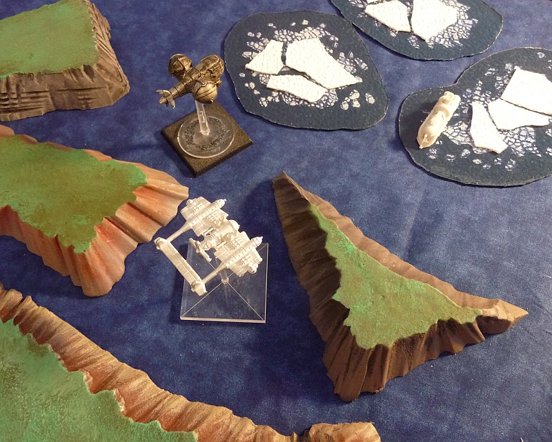
There are two sorts of terrain elements shown here along with some models for scale:

On the right some ice floe patches (with an Empire of the Blazing Sun frigate picking its way through) and on the left some basic islands.

The other minis are a Blazing Sun Bomber and some other mini maker's flying Aeronef of a thing ("Industrial Gothic"[?] maybe...) I have a bunch of the minis but I'm clueless as to what the game was or was about.
The islands are just slabs of foam that were too small to become hills for Warhammer Fantasy. They got re-purposed to a different scale. They are about an inch tall and so represent islands that stand about 100 feet out of the sea.

On the right some ice floe patches (with an Empire of the Blazing Sun frigate picking its way through) and on the left some basic islands.
The other minis are a Blazing Sun Bomber and some other mini maker's flying Aeronef of a thing ("Industrial Gothic"[?] maybe...) I have a bunch of the minis but I'm clueless as to what the game was or was about.
The islands are just slabs of foam that were too small to become hills for Warhammer Fantasy. They got re-purposed to a different scale. They are about an inch tall and so represent islands that stand about 100 feet out of the sea.
Saturday, January 14, 2012
Prussian Icon
This is a logo I built for a friend who has a Prussian Faction fleet for Dystopian Wars.

It is a slight variation on the official Spartan Games Prussian faction flag — mainly it is squared off for use as an icon or avatar, bigger cross, no buzzard, some other details...

It is a slight variation on the official Spartan Games Prussian faction flag — mainly it is squared off for use as an icon or avatar, bigger cross, no buzzard, some other details...
Saturday, December 31, 2011
Tarawa - New Years Day 2012
It is New Year's Eve and as a follow up to the Christmas day map of Christmas Island I have done another map for 1:1200 scale wargaming:
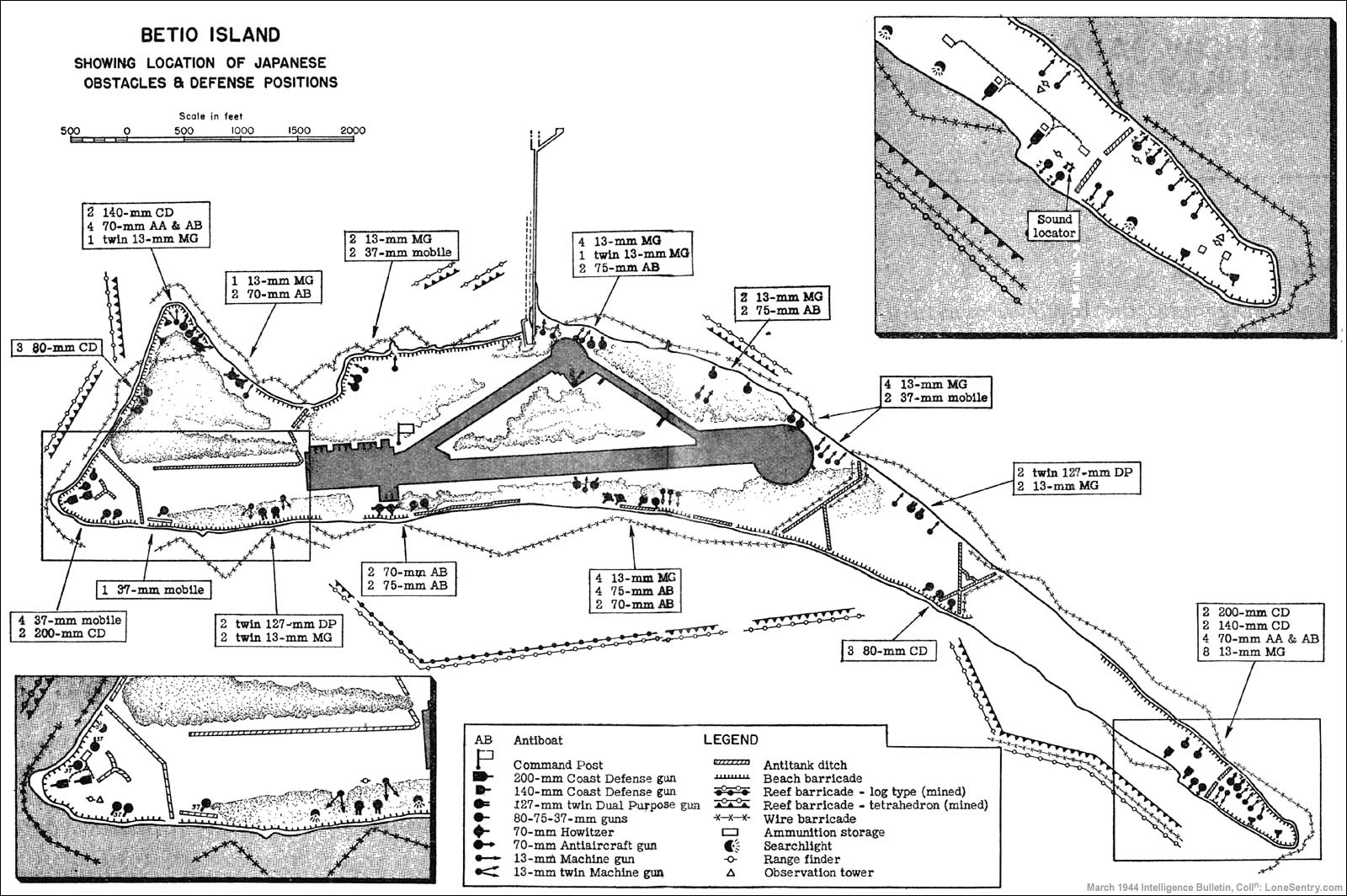
 This is Betio. One of the two dozen or so islets that constitute the Atoll known as Tarawa. This version is somewhat based on a map of Tarawa as it was in 1943 when the USMC took it from the Imperial Japanese Army. The airfield, dock, and compass arrow are as faithful to the source map as possible. The various symbols around the edges of the island represent different 1:1200 scale buildings available from Spartan Games. The grid squares are 12x12 inches (or 1200 scale feet square). The sea squares are filled with two different shades of blue to show that two 4x6 foot tables are needed to model the entire island at a scale of 1:1200.

Sunday, December 25, 2011
Merry Christmas
To celebrate Christmas Day a little map of Christmas Island.
The graphic corresponds to a 48 x 72 inch (4x6 ft) tabletop. To fit on a 4x6 ft table the island has been drawn at a scale of 1:18000. This is 1/15th of the size it would be if it had been drawn at a scale of 1:1200. However the buildings and ships near the airstrip do represent 1:1200 scale models.
The little rectangular inset positioned over the anchorage (northern end of the island; opposite side from the airstrip) is the size of a 4x6 foot table IF the island was modeled at 1:1200.
 |
| Christmas Island — Scale: 1:18000 |
The little rectangular inset positioned over the anchorage (northern end of the island; opposite side from the airstrip) is the size of a 4x6 foot table IF the island was modeled at 1:1200.
Thursday, December 22, 2011
Battlecruiser

The inspiration for this was a thread over on the Spartan Games Forum titled: "Cruisers: what are they good for?" A lot of the netizans posting in the thread believed that Cruiser models were not much use in the game for various reasons. So, I thought what about converting the model to represent something else?
Saturday, December 3, 2011
Deception Island

The various rectangles (red, white, medium blue and also the pale inset area) represent 4x6 ft (48x72 inch) standard gaming tables if the island was modeled at a scale of 1:1200. Note that the whole map is 10x10 tables. Therefore, if the entire map was considered one 4x6 ft table, Deception Island could be modeled on that single table IF the island was modeled at a scale of 1:12000 (that's twelve-thousand) instead of 1:1200.
The triangles mark various summit locations and the tiny red dot in the entrance channel marks a submerged hazard to navigation. The white/royal blue scale bars are (top to bottom) 7200 feet and 2000 meters long.
Wednesday, November 30, 2011
Blazing Sun Icon
This is an icon for use on the Spartan Games discussion forum. It needed a home on the web so it could be linked to. It was originally drawn with AutoCAD, colorized with Paint, and given the beveled effect with an image editor called IrfanView.

It differs from the standard Empire of the Blazing Sun flag in three respects:

It differs from the standard Empire of the Blazing Sun flag in three respects:
- only 12 rays instead 16;
- centered and square instead of offset in a rectangle;
- the rays connect to the center roundel along tangents.
Subscribe to:
Posts (Atom)